Highway
Inspection Services Division
`
Transportation Traffic
Airport
Geotechnical material testing
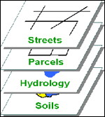
GIS
Structural Eng.
Architecture Eng.
Railway Engineering
NDT
Activties
Gulf House Institute
Branches
Related Links
Data collection including paper/digital maps satellite images, tabular data.
Scanning & Digitizing and Editing.
Raster to Vector Conversion: Contour Map, Sewer Map, Parcel Map, Aerial Image.
GPS data capturing and assurance.
Design and Develop of GIS database.
Data Entry and linking with geographic features.
LMap Production: Symbolizing, Annotation, Map Scale and Printing.
Customized Application Development for Data Management and Quarries.
>>
Back