Highway
Inspection Services Division
`
Transportation Traffic
Airport
Geotechnical material testing
GIS
Structural Eng.
Architecture Eng.
Railway Engineering
NDT
Activties
Gulf House Institute
Branches
Related Links
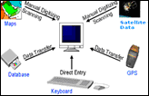
Applying GIS & GPS Technology in Survey, Evaluation and Management for Roads and Utilities.
GPS Training
:: 1st Day
Map projections, The UTM system, The WGS 84 System.
Mapping, Logging, Waypoints and Accuracy.
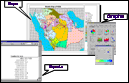
GIS layers and Applying GPS as a tool for GIS.
:: 2nd Day
Road alignment , Static Base-point Survey.
Satellite availability, Database setup.
Updating a GIS dataset with GPS data, Reporting - Printing – Plotting.
>>
Back